
Modeling after topographic maps in Blender
+2
Brook
C14ru5
6 posters
Page 1 of 1

Modeling after topographic maps in Blender
![]() C14ru5 Sat Jan 17, 2009 2:05 pm
C14ru5 Sat Jan 17, 2009 2:05 pm
So, I'm modelling some terrain using Blender and a topographic map overlay. This is done by tracing the contour lines with a Ctrl-LMB click, creating vertices and edges along the way. Everything is going smoothly so far, but I'm beginning to see a couple of problems.
See the following image:
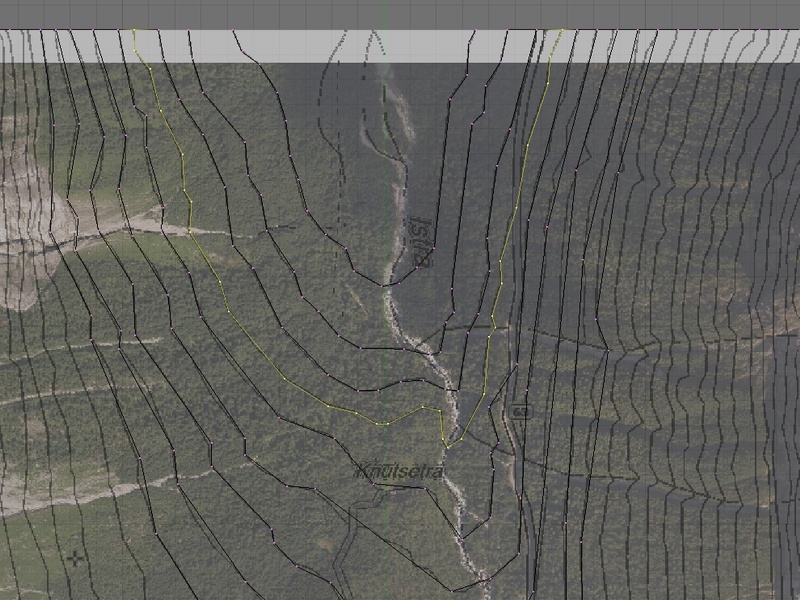
(This is about 1/20th of the whole thing, so it's a pretty serious task that lies ahead of me.)
Problem 1, not so important:
Each contour line that I have traced will (when done) be raised in relation to the next, following the contour interval of my topographic map. So far, the best way I've found to select the proper amount of vertices (like in the image above) is to find a vertex somewhere in the center and Select->More, but it's still a daunting task when the lines get 10x longer than what I have here. Loop select and similar options seems to select absolutely everything. I have a plan B, which is to remove the last edges that connect the contour line to the edges of the plane mesh before I choose loop select, raise the contour line without its extreme vertices, raise those vertices and then reconnect them. Any better ideas?
Problem 2, important:
Sooner or later, I'm going to have to fill the N-gon created between two contour lines with faces. What is the method of choice for this? So far, the only solution I've found is that I need to quadrangulate/triangulate manually and then press F, as Blender doesn't want to make a face if I have more than four vertices selected. That sounds like a terrible job, so I hope there are some clever Blender heads out there that know of a better way. *fingers crossed*
EDIT: I found a half-decent method of solving problem 2, which is to "Fill" using Shift-F and then convert to Quads using Ctrl-J. But due to the editing that needs to be done with the contour lines still isolated, I will have to wait with this method until the very end. It would be nice if there was a better solution.
Oh, and if anyone can help me out here, I might even reveal what I'm working on. Perhaps.
See the following image:
(This is about 1/20th of the whole thing, so it's a pretty serious task that lies ahead of me.)
Problem 1, not so important:
Each contour line that I have traced will (when done) be raised in relation to the next, following the contour interval of my topographic map. So far, the best way I've found to select the proper amount of vertices (like in the image above) is to find a vertex somewhere in the center and Select->More, but it's still a daunting task when the lines get 10x longer than what I have here. Loop select and similar options seems to select absolutely everything. I have a plan B, which is to remove the last edges that connect the contour line to the edges of the plane mesh before I choose loop select, raise the contour line without its extreme vertices, raise those vertices and then reconnect them. Any better ideas?
Problem 2, important:
Sooner or later, I'm going to have to fill the N-gon created between two contour lines with faces. What is the method of choice for this? So far, the only solution I've found is that I need to quadrangulate/triangulate manually and then press F, as Blender doesn't want to make a face if I have more than four vertices selected. That sounds like a terrible job, so I hope there are some clever Blender heads out there that know of a better way. *fingers crossed*
EDIT: I found a half-decent method of solving problem 2, which is to "Fill" using Shift-F and then convert to Quads using Ctrl-J. But due to the editing that needs to be done with the contour lines still isolated, I will have to wait with this method until the very end. It would be nice if there was a better solution.
Oh, and if anyone can help me out here, I might even reveal what I'm working on. Perhaps.

C14ru5- Veteran

- Number of posts : 280
Age : 43
Location : Oslo, Norway
Interests : Student / Synth geek / Vinyl collector
Humor : Don't panic, and don't forget your towel.
Favorite Car : Radical SR4 Clubsport
Favorite Track : Black Forest
Registration date : 2008-08-28
Re: Modeling after topographic maps in Blender
![]() Brook Sat Jan 17, 2009 9:20 pm
Brook Sat Jan 17, 2009 9:20 pm
Am I close?C14ru5 wrote:
...I might even reveal what I'm working on. Perhaps.


Brook- Addict

- Number of posts : 41
Age : 62
Location : The Netherlands
Registration date : 2008-08-28
Re: Modeling after topographic maps in Blender
![]() C14ru5 Sat Jan 17, 2009 10:01 pm
C14ru5 Sat Jan 17, 2009 10:01 pm
I'm reading your post literally and not metaphorically. So, since you're Dutch, I'll have to answer: "Yes, in your mobile home driving 30km/h".Brook wrote:
Am I close?
I don't have any statistics, but there are quite a few Dutch, German and especially Danish flat-country tourists clogging up traffic on Norwegian roads where their cars are seriously out of place. Which brings me to why I want to make a virtual world equivalent, free from any real world frustration. I better make a famous road then, so that the best driving roads known only to locals remain a secret
C14ru5- Veteran
- Number of posts : 280
Age : 43
Location : Oslo, Norway
Interests : Student / Synth geek / Vinyl collector
Humor : Don't panic, and don't forget your towel.
Favorite Car : Radical SR4 Clubsport
Favorite Track : Black Forest
Registration date : 2008-08-28
Re: Modeling after topographic maps in Blender
![]() Brook Sun Jan 18, 2009 12:07 am
Brook Sun Jan 18, 2009 12:07 am
That post was actually a clickable link. This was just me asking if you were making the Troll Ladder...C14ru5 wrote:I'm reading your post literally and not metaphorically.Brook wrote:
Am I close?
Brook- Addict
- Number of posts : 41
Age : 62
Location : The Netherlands
Registration date : 2008-08-28
Re: Modeling after topographic maps in Blender
![]() C14ru5 Sun Jan 18, 2009 6:12 am
C14ru5 Sun Jan 18, 2009 6:12 am
I know, and your link was followed before I gave my tongue-in-cheek answer. 
No more hints for you.
No more hints for you.
Last edited by C14ru5 on Sun Jan 18, 2009 6:14 am; edited 1 time in total (Reason for editing : Added smileys for dramatic effect.)
C14ru5- Veteran
- Number of posts : 280
Age : 43
Location : Oslo, Norway
Interests : Student / Synth geek / Vinyl collector
Humor : Don't panic, and don't forget your towel.
Favorite Car : Radical SR4 Clubsport
Favorite Track : Black Forest
Registration date : 2008-08-28
Re: Modeling after topographic maps in Blender
![]() slowDan Sun Jan 18, 2009 10:36 am
slowDan Sun Jan 18, 2009 10:36 am
The L key is your friend! Make sure your mouse is close to the line you want and press L. This should select all the vertexes which are connected to the one you are closest too. As long as each line is separated that should do the trick.C14ru5 wrote:
Problem 1, not so important:
I can't really think of a good solution for Problem 2 though. You are going to need to make manual decisions at some point, as any automatic method could well end up with a square where you wanted a triangle or other strange ideas!

slowDan- Addict
- Number of posts : 92
Age : 51
Location : UK
Interests : Design/Racing!
Favorite Car : Porsche 968 RS Turbo
Favorite Track : Spa Francorchamps
Registration date : 2008-08-28 -

Re: Modeling after topographic maps in Blender
![]() Kenners Sun Jan 18, 2009 11:46 am
Kenners Sun Jan 18, 2009 11:46 am
Problem 1: When you start on a particular contour line, and you create that first vertex, don't you set its elevation right then? Then as you extrude that vertex over & over, they all retain the same elevation... Right? What have you been doing?
Problem 2: I can't see any way either, except *click* *click* *click* f over & over & over.....
-K
Problem 2: I can't see any way either, except *click* *click* *click* f over & over & over.....
-K
Kenners- Veteran
- Number of posts : 240
Age : 61
Location : Grand Junction, Colorado
Registration date : 2008-09-11
Re: Modeling after topographic maps in Blender
![]() C14ru5 Mon Jan 19, 2009 5:37 pm
C14ru5 Mon Jan 19, 2009 5:37 pm
It's not extrusion, but more a "trail of crumbs". First I draw all the contour lines on a flat plane, then I select the contour lines and raise them to where they're supposed to be (as a single contour line represents one exact elevation). A quite technical solution, but it works surprisingly well. The time-consuming part is making all the edges and faces.Kenners wrote:Then as you extrude that vertex over & over, they all retain the same elevation... Right? What have you been doing?
Thanks for the good advice, guys. It has helped me approach this project from new angles. The best solution I found for Problem 1 was to remove the outermost edges of the plane, then select the lines using the L key like slowDan suggested. Expanding on this method, I found a way to shave off a good amount of work: By creating edges between every other vertex along the edge of the plane, I create several loops that work well enough with Fill (Shift-F) and Beautify Fill (Alt-F). Of course it doesn't work everywhere - only for contour lines that touch the outer edges of the plane, and not for the "islands" that make up the mountain tops. And weird geometry does occur every now and then, so I still need to watch the process carefully.
I sense a tormenting task ahead of me, connecting all those vertices and creating new faces, wearing out one right mouse button and a Shift-pressing pinky in the process. But it looks very promising so far. Picture:
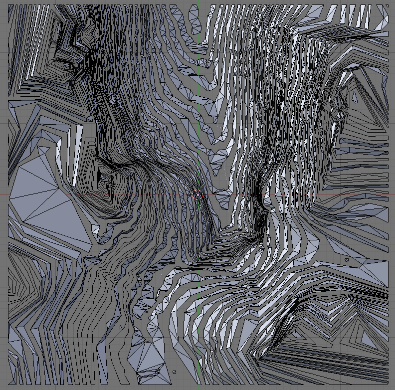
Looks a bit like modern art, doesn't it? I'm not showing you anything other than top view yet
C14ru5- Veteran
- Number of posts : 280
Age : 43
Location : Oslo, Norway
Interests : Student / Synth geek / Vinyl collector
Humor : Don't panic, and don't forget your towel.
Favorite Car : Radical SR4 Clubsport
Favorite Track : Black Forest
Registration date : 2008-08-28
Re: Modeling after topographic maps in Blender
![]() Andreu Mon Jan 19, 2009 7:14 pm
Andreu Mon Jan 19, 2009 7:14 pm
Interesting stuff.
All this got me thinking about displacement maps in blender, i.e. the use of the Displace modifier. I wonder if there is a way to control with some level of precision and predictability the height of the target polygons in relationship to the darkness value of the corresponding pixels. Hm, now I can even start seeing some advantages to using the Posterize filter in Photoshop...
All this got me thinking about displacement maps in blender, i.e. the use of the Displace modifier. I wonder if there is a way to control with some level of precision and predictability the height of the target polygons in relationship to the darkness value of the corresponding pixels. Hm, now I can even start seeing some advantages to using the Posterize filter in Photoshop...
Andreu- Rookie

- Number of posts : 5
Favorite Car : Built-in Golf, Lancia Fulvia
Favorite Track : Built-in Rally Track, Silverstone, Brands
Registration date : 2008-12-01
Re: Modeling after topographic maps in Blender
![]() slowDan Mon Jan 19, 2009 7:19 pm
slowDan Mon Jan 19, 2009 7:19 pm
That's putting it mildly! I dread to think of how to even begin to put a road in there, good luck.C14ru5 wrote:I sense a tormenting task ahead of me,

slowDan- Addict
- Number of posts : 92
Age : 51
Location : UK
Interests : Design/Racing!
Favorite Car : Porsche 968 RS Turbo
Favorite Track : Spa Francorchamps
Registration date : 2008-08-28 -
Re: Modeling after topographic maps in Blender
![]() C14ru5 Mon Jan 19, 2009 8:20 pm
C14ru5 Mon Jan 19, 2009 8:20 pm
That's what the rlplist road exporter python script is forslowDan wrote:how to even begin to put a road in there
I've already done some small-scale experiments.
That seems to be exactly what the displacement map feature is for! I understand that it can produce staggering results, but mainly for creative purposes, it seems. Come to think of it, I probably could color the white areas of the topographic map in different shades of gray according to their height and use it as a displacement map. A bit hard to get things smooth then, but very practical if someone wants to make the agricultural terraces of Machu Picchu...Andreu wrote:... Displace modifier. I wonder if there is a way to control with some level of precision and predictability the height of the target polygons in relationship to the darkness value of the corresponding pixels.
Anyway, I'm now so far into this method that I'll leave that experiment to someone else.
C14ru5- Veteran
- Number of posts : 280
Age : 43
Location : Oslo, Norway
Interests : Student / Synth geek / Vinyl collector
Humor : Don't panic, and don't forget your towel.
Favorite Car : Radical SR4 Clubsport
Favorite Track : Black Forest
Registration date : 2008-08-28
Re: Modeling after topographic maps in Blender
![]() slowDan Tue Jan 20, 2009 4:10 am
slowDan Tue Jan 20, 2009 4:10 am
D'oh!C14ru5 wrote:That's what the rlplist road exporter python script is for

slowDan- Addict
- Number of posts : 92
Age : 51
Location : UK
Interests : Design/Racing!
Favorite Car : Porsche 968 RS Turbo
Favorite Track : Spa Francorchamps
Registration date : 2008-08-28 -
Re: Modeling after topographic maps in Blender
![]() NoNameBrand Tue Jan 20, 2009 12:21 pm
NoNameBrand Tue Jan 20, 2009 12:21 pm
Why are the bits all disjointed?
I would have created a plain, then done the lowest contour line, and raised the inside face to it's appropriate height, and then made an inner contour line, and raised that, repeating this process for each peak.
I would have created a plain, then done the lowest contour line, and raised the inside face to it's appropriate height, and then made an inner contour line, and raised that, repeating this process for each peak.
NoNameBrand- Veteran
- Number of posts : 321
Age : 43
Location : Halifax, NS
Interests : guitar, photography
Humor : ...is properly spelled 'humour'.
Favorite Track : Spa-Francorchamps
Registration date : 2008-08-28 -
Re: Modeling after topographic maps in Blender
![]() C14ru5 Wed Jan 21, 2009 7:46 am
C14ru5 Wed Jan 21, 2009 7:46 am
That's what I would have done as well, if I had been doing this in Wings3D, where the faces and normals always remain intact whenever you delete and reconnect vertices during subdivision modeling. In Blender, this method isn't as fruitful, as rearranging edges requires you to make new faces as well. The method I used here follows the same idea that is presented in Blender's "From Noob To Pro" tutorial. It's hard to say what method would be the quickest of the two - my method was very effective in the beginning, but then became very tedious in the end.NoNameBrand wrote:would have created a plain, then done the lowest contour line, and raised the inside face to it's appropriate height, and then made an inner contour line, and raised that, repeating this process for each peak.
Result after all faces have been created:

Thanks for the help along the way, I'll now need to add the road and the textures. Updates will be posted in the development thread.
C14ru5- Veteran
- Number of posts : 280
Age : 43
Location : Oslo, Norway
Interests : Student / Synth geek / Vinyl collector
Humor : Don't panic, and don't forget your towel.
Favorite Car : Radical SR4 Clubsport
Favorite Track : Black Forest
Registration date : 2008-08-28
Page 1 of 1
Permissions in this forum:
You cannot reply to topics in this forum